DRONE BUILDERS: NEW EMPLOYEE AT YOUR CONSTRUCTION SITE

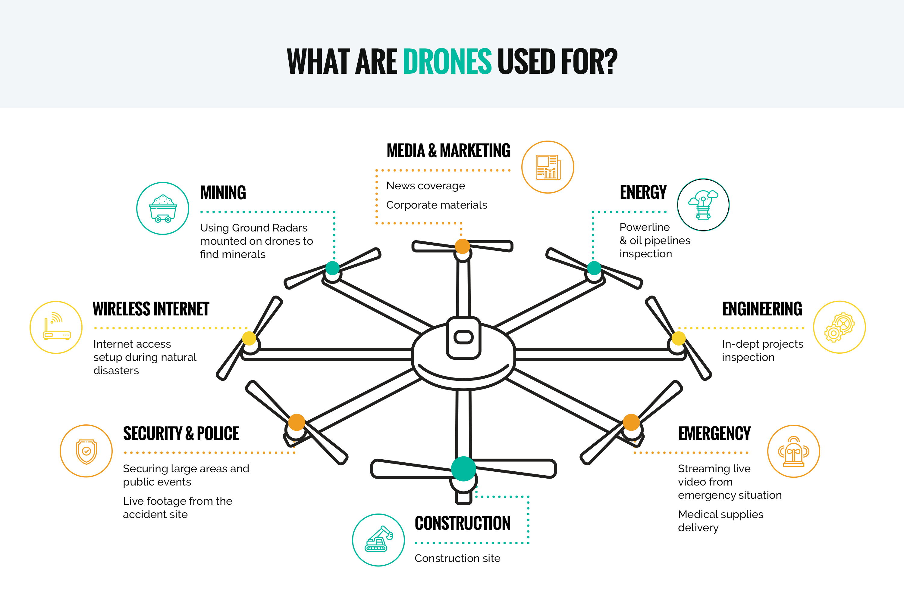
Drones perform multiple functions and can be used virtually in any industry. Goldman Sachs forecasts a $100 billion market opportunity for drones as powered by growing demand from the commercial and civil government sectors: $45 billion (infrastructure), $32 billion (agriculture), $13 billion (transport), and $10 billion (security). Drone use by builders is rather promising as drones can be introduced at any construction and development stage.

What can drones do at a construction site? Drones can optimize the construction process in various unexpected ways. Let’s talk about the following three functions:

1. Construction progress control
2. Assessment of emergencies
3. Building Information Modeling

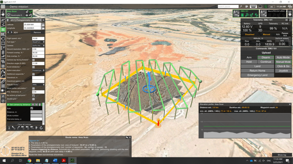
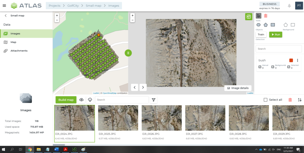
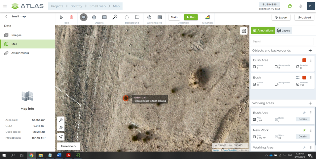
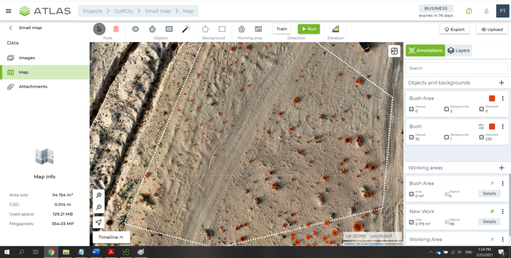
Construction progress control helps to acquire information on construction site changes over specific period and compare current status with planned construction documentation. Drone flies around the construction site in an automated mode, while also taking photos and making orthophoto-, 3D- and landscape maps. The accumulated data goes to a private web portal accessible to responsible persons and construction stakeholders only, thus contributing to fast and streamlined communication between construction participants, as well as easier control over staff performance.

Drones also provide ad-hoc monitoring of the location of construction machinery, construction materials and temporary facilities. Small-sized drones can approach hard-to-reach engineering components.

Assessment of emergencies. In case of emergency, a drone flies on site to take photos and shoot videos, with all information being sent online to a situation center for prompt issue resolution. In addition, drones can perform live broadcasting.

Building Information Modeling. Drone photogrammetry makes it possible to not only match a certain construction stage with the plan but also then deliver an eye-catching site presentation in 3D. Once construction is over, a drone flies around the completed site and collects data to be then transformed into a precise 3D model of the facility. Such a model can be easily presented on a holographic table, a new presentation tool for real estate segment. 

Drones are compatible with various advanced technologies (e.g. video analytics, BIM, drone show software and security solutions) and thus can be used almost in any sector.

Your personal AI for efficient and fast industrial inspection: ATLAS, drone, and desert bush counting

Your personal AI for efficient and fast industrial inspection: ATLAS, drone, and desert bush counting

Any industrial inspection solves three main tasks: data collection (photos of objects), analysis (identifying defects and abnormalities), and reporting. Today, Pavel Tatarintsev will talk about ATLAS – image analysis and automatic reporting system that covers the most labor-intensive industrial inspection tasks.

Article by Pavel Tatarintsev, NNTC R&D Head
LinkedIn | Mail

Naturally, ATLAS is not the first solution on the market that analyzes photos and automates reporting, but its unique easily trainable AI module makes it a truly handy and unparalleled tool.

How I taught ATLAS to find bushes in the desert

I will describe the module operation using my own user experience as an example. One weekend, I decided to go to the desert and, just for fun, teach my ATLAS to recognize bushes. It was an easy, interesting, and clear process. I used a standard laptop with installed UgCS and ATLAS software, as well as a 400g DJI Mavic Air drone with a built-in wide-angle camera. This is a small, quite popular and affordable drone.

First, an engineer needs to draw a route for a drone in UgCS (below is the screenshot of my drone’s route). I set the frequency of taking photos and the following parameters. It took my drone 15 minutes to fly around three hectares.

drone industrial inspection

As a result, I got approximately 100 photos for analysis.

industrial inspection

I uploaded the photos to ATLAS, which, in 5 minutes, created an area map with the relief. As I wanted ATLAS to learn how to find bushes, I then used a marker to outline the bushes on some 20-30 photos and launched a search by photos.

In 20 minutes (including AI training and photo search), I got my result. The program managed to count not only the number of bushes, but also (if needed) the total area covered by them. Indeed, you can set any parameters and reporting targets for this flexible and intelligent solution.

ATLAS

It is efficient, isn’t it? I believe very much so. Now imagine that the solution can find not only bushes, but also cracks on roads, rust on metal structures (for example, rusty spots on ships), oil spills, and any other things or flaws that the built-in AI can learn.

Is it easy to teach ATLAS AI for drone industrial inspection? Depends on what you want it to learn. When it comes to rusty spots on the pipe surface, all it takes is just a few photos with outlined spot examples. But if you need AI to find a green car in the green leaves, it’s more challenging and the system will need more examples for training.

ATLAS and industrial inspection tasks

Let me tell you the story of one of our customers (without mentioning its name). Our customer bought a ‘fixed-wing’ drone (a plane-like model that can fly continuously over long distances, collecting necessary data) and had a camera installed on it to shoot the sea surface. The drone flew and brought back 12,000 photos to be analyzed for oil spills. Just imagine how long it would take to manually analyze and document all these photos. Plus, oil film is often very difficult for the human eye to see on the waves. Nevertheless, the customer successfully addressed the challenge opting for ATLAS that was taught by an engineer to promptly find oil spills on photos.

oil spill industrial inspection

This solution is also used to fly around and inspect the condition of oil pipes and production facilities, survey vegetation, as well as scan object surfaces, soil, and asphalt. The solution can be easily applied virtually in any sector and for any task. You can even set it the task to not only looking for defects but also rank them by hazard.

This is how artificial intelligence facilitates inspections and ensures control over the safety of both facilities and the environment. All you need to do is ‘explain’ ATLAS what task you want it to solve.

If you have any questions about drone industrial inspection, please go to the solution page on our website, subscribe to my blog, or message me on LinkedIn.

Read more

“THE DRONE ILLUSION” FROM THE ENGINEERING PERSPECTIVE

Drones are modestly sized unmanned aerial vehicles making headline news and buzzing around. They are featured in spy action movies and video games playing the role of enemy technology or helping a protagonist to outplay enemies. Either way, this stunning fictional representation lures our minds into a trap of “the drone illusion”. To pierce this veil, let’s take a look from the engineering perspective.

Engineering considers aerodynamic efficiency of a drone design and numerous factors, including the laws of nature equally applying to everyone and everything.

We need a vehicle perfectly performing functional tasks, which, in our case, takes off at once, hovers steadily, and transports cargo over long distances. We need…a helicopter. During the last 50-60 years, the appearance of all helicopters remains virtually the same, in general, there are two main aerodynamic designs. Why so? Helicopter is the proven golden standard in fuel efficiency, agility, and effective load-carrying capability. Coaxial rotor helicopters, for instance, are the most fuel-efficient. (Coaxial rotors are a pair of helicopter rotors mounted one above the other, with the same axis, but rotating in opposite directions). Such a sophisticated machine design requires not one, not a dozen, but a huge task force that includes specialists highly qualified for the job.

As for drones, they are compact, lightweight, and easy to assemble – you don’t need an engineer’s degree to make such a flying device for yourself. And let’s make it clear: all drones are aerial vehicles, but not every drone is created by professional engineers specializing in aerodynamics. The industry has a few companies engaged seriously with drone designing. Though there are many young talents bubbling with enthusiasm to write an excellent code and solve challenges and, of course, impatient to field-test it. Sometimes, a team intentionally sacrifices aerodynamic efficiency in favor of easier and faster development. However, even if they installed a software masterpiece on such a drone, its power would still be limited by design. Plenty of original ideas remain untranslated into reality without a professional engineer in a team.

Drones come in a great number of shapes and sizes, but the majority has two weaknesses:

  • Low energy efficiency, as compared to helicopters, which limits both the flight time and load carrying capability
  • Poor flexibility and balance, as compared to the bigger brother

When it comes to business tasks, people start talking about drones and fall into the trap of their own illusions about drones. It goes like this: “We want you to develop for us a drone that can…blah-blah-blah”. Is it really a good way to solve a business problem?

Let me tell you one story about agricultural business. Thirty or so years ago, small helicopters were actively used to spray the fields. Since then, their market share has been slashed, while drones’ share has increased. Back to the business task: transportation of chemicals to spray the fields. To be more or less effective, a drone has to be capable of spraying 15-20 liters per flight. Before drones, the market supplied radio-controlled helicopters carrying 15-30 liters of chemicals, thus significantly dropping the cost of treating one hectare, as compared to conventional methods. Today, an agricultural drone – a bulky and barely transportable vehicle worth of $25,000 to 30,000 USD – can carry some 15-16 liters of liquid. Just compare: a modern helicopter with the same load carrying capacity costs $10,000 USD, but it flies faster and more flexibly, and its battery works longer. Moreover, it is easy to transport – you can fold the rotors and put its body in a car trunk. This is the trap of “the drone illusion”: helicopter costs less and works better, but drones grow in demand.

“The drone illusion” hurts the industry. In fact, the existing drone design simply can’t get better, as technology evolves evenly for all aerial vehicles. Should the drone battery improve, the helicopter’s will improve too. Thus, the developers with more experienced in-house engineers will have a competitive edge.

How to avoid “the drone illusion” trap? Actually, it’s easy. Drones can effectively solve certain tasks. Take logics to a new level: don’t try to adapt drones. Start searching for the right flying vehicle and consult with an engineer. This will help you save money, avoid hassle, and expand the technological capacity. Discover the richness of technology of the 21st century.

by Pavel Tatarintsev, NNTC R&D Head

DRONE SHOW: WHO’S PULLING THE STRINGS?

Sorry, fireworks, it’s been a pleasure looking at you, but you are out. We are looking for something else to take our breath away. Dancing drones is a new trendy thing, giving people a thrill of fresh experience – same sparkling lights, but smart. But how does it work? Let’s take a peep behind the scenes and watch show creators at work.

If there is a swarm of 300 or 1,000 drones, imperfections in their position against one another and the ground are scarcely noticeable – this vigorous whirling formation of pieces of light, each separated by a few meters from the rest, is too big, and any error or desync is almost invisible. Even if a couple of drones just fall down, it’s no bother. Though it’s not the case for hotels and parks preferring drone show of 20 to 90 flying dancers. There is no margin for error and drones are expected to move in perfect harmony. So, how to prepare a drone show? You can’t just make these vehicles pirouette in the air with perfect timing, can you?

Step one. Drones
For a start, you need to set your fleet ready for the show, i.e. make sure every drone is unbroken, properly configured, and nothing is missing after transporting. We at NNTC prefer to operate ready-to-use DJI drones or assemble them ourselves. 

Step two. Staging the show
It all starts with 3D modeling.

Motion graphics created in Blender, for example, is converted from animation trajectories to a format readable by the autopilot. Before going to the field, we perform thorough testing involving simulators. We put virtual instances of drones into necessary coordinates and operate them as real appliances using our software. This way we can evaluate their flight in real-time, as well as visualize the outcome in a 3D scene.

Here, have a look:

Step three. Harmony
To ensure precise movements and perfect timing, you will need a special software, for example, Drone Dance Controller produced by our vendor UgCS. The programming team worked hard on the autopilot that navigates the ballet of drones along random trajectories with accurate GPS time synchronization. The trajectories can be drawn using either a 3D computer graphics software or scripts. Now, when everything is set, all an operator needs to do is press ‘Start’ and watch the show closely.

Step four. Test
We can finally test everything in practice and see what drones can actually do. We deploy our infrastructure (ground control station and communications), arrange drones, and check if all of them are OK after transportation and can be connected to our station. The software will then automatically determine a route for each particular drone. Finally, we set a start time, and off we go!

Step five. The show
Now you’re ready. During the flight, both the operator and other people in charge need to monitor the fleet condition and, if necessary, decide to perform the emergency landing of a drone, which is out. Remember, you should mind certain restrictions before starting the show. No ‘whatever the weather’: rain or wind speed of over 5 m/s is likely to ruin the accuracy of drone’s position in the air. To communicate with drones, we need radio frequencies being rather free from other signals. Spectators need to be at a certain distance from the show venue for their own safety.

Watch how the drone show must go on:

We bring the most ambitious fantasies, ideas and dreams to life with drone and laser shows. Visit this page for more information, if you are looking for how to order a drone show, or if you want to talk to an expert and learn how the drone show will work for your occasion and venue.

How Face Recognition System Puts Things Right on Construction Site and Helps Contractor Avoid Penalty 3

A mess on a construction site is quite a common thing and can be tolerated to some extent if it is an organized mess. However, when this mess creeps into core processes, a construction site turns into a hurrah’s nest, and a developer faces risk of large penalties, downtime, and even death toll. In this blog, we’ll tell you how CROC, our strategic partner, implemented a face recognition system on a construction site.

One fine, sunny day, when the site was buzzing with activity and dozens of workers were moving around cheerful and positive, a former workman penetrated the site. He passed through a checkpoint, greeted a guard who knew him well (but did not know that he had been fired already), entered the territory, and went to his friends. Half an hour later, a fire was burning, with the workers drinking tea, resting, and enjoying their lives.

The problem was that they made the fire near two gas cylinders, one of which suddenly exploded. Neither warning nor alert. Just exploded, and that’s it! Fortunately, people were just shocked, not injured, but a police came to the site the same day and initiated an inspection, which revealed some unpleasant facts for a contractor:

  • Many workers used forged documents. In other words, one family member obtained necessary documents, got hired at the construction site, and then his brother went for work instead of him.
  • For each worker using forged documents, a fine of $7,600 or even more may be imposed, and the construction process may be suspended for 14 – 90 days with almost catastrophic consequences for a general contractor and customer.

That is why the contractor asked CROC for help.

How to solve a problem?

Initially, the construction site was equipped with just run-of-the-mill employee recognition systems:

  • Palm vein identification, which performs poorly even in clean offices if people eat some greasy food there. After eating, this vein pattern changes causing recognition errors.
  • Iris identification, which is more expensive and time consuming. It is hardly the best option when every morning buses arrive at a construction site and some 600 workers have to pass the checkpoint within one hour, from 7 to 8 a.m. It’s as slow as a snail!

Therefore, it was the time to try video analytics.

Each turnstile is equipped with two cameras: one aimed at incoming people, and the other, at outgoing.

There is a small cooled server room on site, having a rack with two servers and a switch. The first server receives video stream from cameras and identifies frames containing faces and being of the best quality. The second server receives these “clear” frames with faces and runs a recognition algorithm to find a match in a database.

If a frame contains only one face and this person is authorized to pass through, then the turnstile opens. Otherwise, a guard is alerted.

No Internet connection is needed for the system, just a copper cabling on site. However, if connected, the system allows for continuous monitoring, email reports, and remote second line support for operators.

The system runs perfectly in typical situations:

  • Using a pass card of another person to enter — an alerted guard stops a trespasser and investigates the incident.
  • A former employee attempts to enter the site — a guard does not let him in.
  • An employee attempts to enter the site in wrong time — a guard asks the employee to get a pass card at an access control office and then come back to the checkpoint.

In addition, every evening, executives get a report on how many people were scheduled for work and how many arrived actually. It is very important since contractor’s favorite trick is to schedule 50 workers, provide only 30, and then report on 50.

Moreover, this information — like 600 people scheduled, only 450 arrived — shows if a project is running out of time already. And you see it right now, but not a week or month later.

Outcome

Morning queues have almost disappeared. Instead, it takes one hour for two turnstiles to let 700 people in, even including guard intervention cases. The customer enjoys reports on the actual number of people arrived at the construction site, which was a sad news for some of the contractors. Neither a $7,600 penalty nor work suspension for 14 – 90 days is pending now, with the system itself costing less than this penalty.

NNTC actively partners with CROC and implements face recognition solutions in GCC countries. If you are interested in this technology, feel free to contact our consultants.

FACTS BEHIND THE DAZZLE OF A DRONE LIGHT SHOW

Just as drones popularity has been increasing rapidly in the past few years they are perceived as the instruments allowing to go beyond the bounds and thus being adopted massively by the entertainment industry. Here are the facts behind the dazzle which will make you consider a drone light show for your next event!

DRONES COMBAT ILLEGAL FISHING

How can drones help fight illegal fishing? Let’s discuss the most common use case.

To detect and track illegal fishing vessels in the sea, a drone has to cover the largest possible area during one flight. In addition, drones should carry cameras to take photos and videos, powerful transmitters to stream video to a command center, and high-capacity batteries to ensure long operation.  

Today, responsible authorities use long-range fixed-wing aircraft, which meets the above requirements, but at the cost of convenience and flexibility:

  1. Fixed-wing aircraft requires an airstrip to take off and land. This limits a mobility and patrol area.
  2. If no airstrip available, a catapult is required for take-off and a parachute for landing. Unfortunately, catapult needs transportation and time for deployment. Parachute system adds weight to the aircraft thus reducing the range and/or payload.
  3. Fixed-wing aircraft is, basically, a plane. A skilled pilot is required for take-off, fly and landing, otherwise aircraft will crash. 

To overcome the above limitations, while keeping the required drone range, VTOL aircraft can be used. Recently, the market saw a lot of announcements of VTOL aircrafts ranging from small 1.5 m wingspan to larger 4 m ones.

Such aircrafts uses two major designs: a) tilt rotors, where the same motors and propellers are used for take-off and landing, and b) aircrafts that use propellers for horizontal flight and dedicated VTOL rotors for take-off and landing. Dedicated VTOL propellers are easier to build and maintain, however, they create additional drag during horizontal flight, thus reducing aircraft flight range. On the other hand, tilt rotors require additional mechanics to operate.

Overall, despite above trade-off, VTOL aircrafts can greatly increase the efficiency of patrolling operations in illegal fishing fighting mainly due to possibility to change patrolling areas easily.