UAV & Satellite Data Analysis
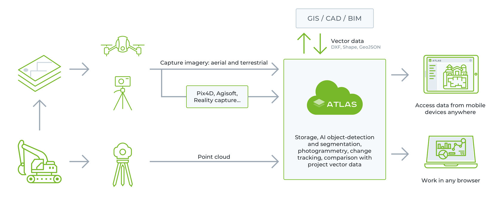
ATLAS platform automates regular tasks of analyzing geospatial data from drones and helps track changes, securely store aerial imagery, and share reports in just one click.
ATLAS digital platform employs artificial intelligence (AI) to automate UAV & Satellite data analysis routines, such as detecting and counting objects, measuring volumes, making a true digital terrain model (DTM), and many more. Such manual operations used to take a lot of time, but ATLAS runs on a proprietary AI-engine, which can be trained by user, and thus enables a 10-times faster data analysis.
CONSTRUCTION PROGRESS MONITORING
Provide your teams and stakeholders with up-to-date information as early as the day of survey. No more delays due to manual data analysis routine.

MORE EFFECTIVE TEAMWORK AND COORDINATION
Increase situational awareness of all project stakeholders by keeping data on the timeline in a very simple and straightforward manner. Share data in just one click as direct links accessible from a mobile device (iOS/Android) and desktop.

SENSITIVE DATA SECURITY
Install ATLAS on premise to ensure your most sensitive data is stored, processed and exchanged in a secure environment.
Automate regular UAV data analysis tasks
ATLAS allows any user without GIS or data science knowledge to train and operate AI algorithms to solve specific data analysis tasks, from object detection to elevation mapping.
Progress Tracking
Compare as-is construction site as orthomosaics with a DXF plan to control various construction processes.
Cut and Fill Reports
Enjoy simple and clear ATLAS reports to stockpile volume measurements and thus make earthworks more efficient.
Object Counting
Leverage automated object detection and territory segmentation tools to instantly detect roads, building footprint, solar panels, vehicles, vegetation, crossroads, and any other regular objects.
Elevation Mapping
Create more realistic elevation profiles by cleaning vegetation and artificial objects from DSM.
Asphalt or Concrete Inspection
Detect cracks and scratches on concrete and asphalt surfaces, localize defects and assign resources to mend them.
Reforestation and Land Rehabilitation
Employ ATLAS to regularly monitor the planted vegetation and calculate the total number of trees in the plot.
Locating asphalt cracks on the road surface
Read how Construction & Civil Engineering Company from Mexico automates road surface analysis and generates web maps with detected road defects for further road maintenance.
UAV data analysis at construction site