Static renders, brochures, PDFs, and floor plans are still standard tools in off-plan property marketing, but they often fall short when buyers need clarity most. They can make a project look appealing, yet still leave buyers unsure about space, layout, surroundings, and the real difference between available options.
That is where static content starts to work against the sales process. Instead of helping buyers compare and decide, it often forces them to piece the project together from disconnected visuals and technical documents. The result is a familiar problem: interest is created, but commitment slows down.
For developers, this is not just a content issue. It affects buyer confidence, makes shortlisting harder, and creates extra pressure on sales teams to explain what the material itself should already make clear.
Static content shows, but it rarely explains:
A render can make a project look impressive. A brochure can list amenities and highlight value points. A floor plan can show dimensions and layouts. Each of these has a role in off-plan property marketing. In the National Association of Realtors’ 2024 buyer profile , 41% of buyers said photos were still useful; buyers rated photos, detailed property information, and floor plans among the most useful content formats in the search process.
That matters, but it also highlights the limit of static assets: they help buyers notice a property, yet do not always help them fully understand it.
The real problem is that buyers are not making decisions from isolated pieces of information. They are trying to answer more practical questions. What does this unit actually feel like compared with another one? How does the project sit within its surroundings? What is the difference between one view, one floor, or one building and the next? How do I picture daily life in a place that does not yet exist?
Static content struggles with those questions because it is fragmented by nature. It presents information in separate pieces, while buyers need connected understanding. That is why more interactive formats are becoming more important in off-plan sales.
In NNTC deployments, interactive sales tools have helped increase consultation-to-reservation conversion by 18%, suggesting that buyers move forward more confidently when they can explore a project in a clearer and more connected way.
What makes buyers hesitate even when they like the project:
Hesitation usually comes from three gaps.
They cannot understand space properly:
A floor plan can communicate dimensions, but not the lived sense of space. It does not show how a room flows, how a layout feels, or how different parts of the home relate to each other in practice. That is why more interactive formats are gaining ground.
They struggle to compare options clearly:
Off-plan decisions usually involve many variables at once: size, layout, view, floor level, building position, orientation, and price. Static brochures and PDFs make comparison harder because they separate information instead of bringing it together. Buyers are left to piece together the project from disconnected files instead of evaluating it in one place.
That is one reason more interactive formats are gaining attention. Zillow reports that homes with an Interactive Floor Plan were saved 79% more than homes without one, which suggests buyers engage more when layout and navigation are easier to understand.
As a result, buyers often leave the conversation with too many files, too many screenshots, and too little clarity.
They cannot fully trust what they cannot explore:
A render can be beautiful, but it is still a controlled image. Buyers know that. They understand that marketing materials are designed to present the project in the best possible light.
What they often lack is the ability to explore the project more freely and build confidence through their own interaction. That gap matters because buyers themselves say richer formats help them judge a property more clearly.
Another study by Zillow reports that 74% of prospective buyers agree that 3D tours help them get a better feel for a home’s space than static photos, and 70% wish more listings offered them. In other words, trust builds more easily when buyers can explore rather than just observe.
Why remote buyers and international buyers need more than static content :
The challenge becomes even sharper when the buyer is not physically present. Remote and international buyers usually depend almost entirely on digital material. If that material is limited to static renders, PDFs, and floor plans, the project becomes harder to understand and harder to trust. There is less room for discovery, less emotional connection, and less confidence in comparing one option against another.
This is where a connected sales experience becomes far more useful. Tools such as a web-based 3D walkthrough or an interactive showroom experience bring units, views, and surroundings into one place, giving remote buyers a clearer and more engaging way to explore the project.
That is a commercial problem, not just a content problem.
If remote buyers cannot engage with the project in a meaningful way, developers lose momentum at one of the most important stages of the sales journey.
Static content also creates friction for sales teams:
The problem with static content is not only that it limits buyer understanding. It also becomes difficult to manage at scale.
In most off-plan sales setups, brochures, floor plans, renders, website assets, showroom presentations, and follow-up materials are created as separate pieces. Over time, those pieces can drift apart. A unit update may appear in one place but not another. A visual used in a campaign may not match what sales teams are sharing later in the journey. What starts as a content stack quickly becomes a coordination problem.
For developers, that creates unnecessary friction. Instead of supporting one coherent buyer experience, static materials often produce multiple versions of the same project across channels. The result is not only more work for sales and marketing teams, but also a higher risk of inconsistency at the exact point where buyers need clarity.
What developers can do instead :
The answer is not to abandon renders, brochures, or floor plans. They still have a role in off-plan property marketing. The issue is relying on them alone to carry the full buyer journey.
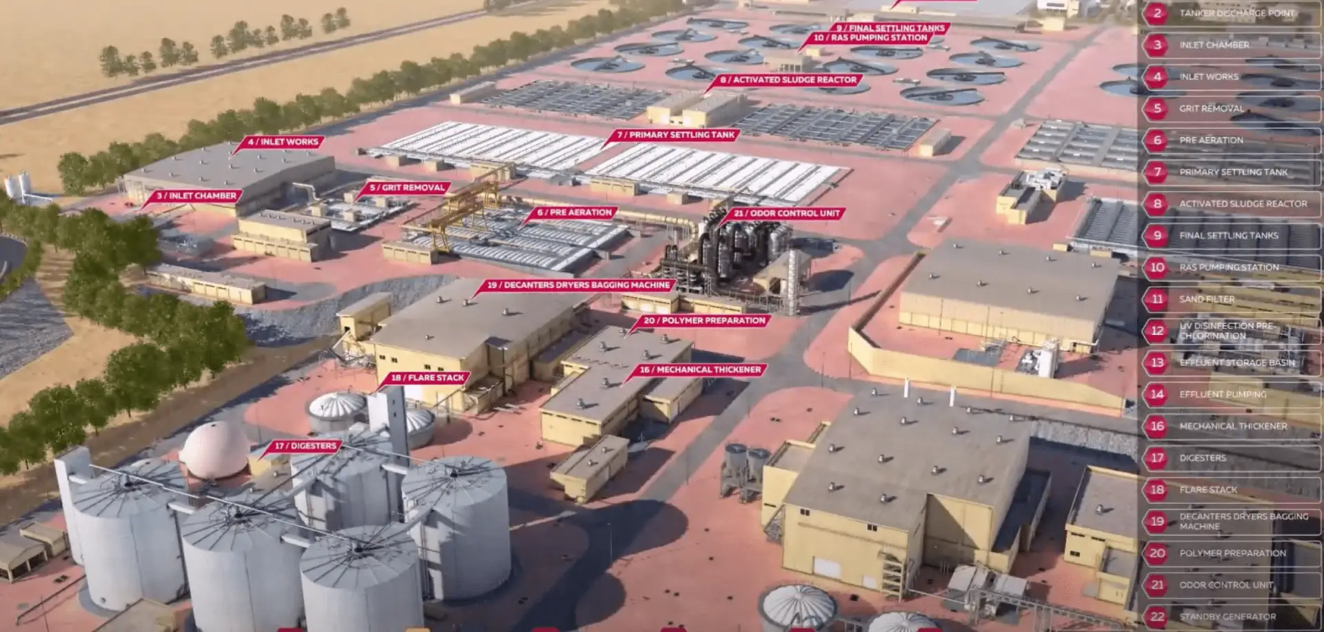
What developers need is a more connected way to present the project, one that helps buyers move from first impression to real understanding. Instead of showing isolated assets, a stronger sales experience brings the project together in one explorable environment.
That is where digital twins become valuable. A digital twin allows buyers to explore the development more freely, understand how units relate to the wider project, compare options more naturally, and build confidence through interaction rather than guesswork. For sales teams, it creates a more unified way to present the project across website journeys, showroom consultations, and remote conversations.
The commercial case for that shift is already visible in NNTC deployments. After introducing interactive 3D sales apps, residential projects saw a 12% boost in reservation-to-sale conversion. In other words, when buyers can explore a project in a clearer and more connected way, they are more likely to move forward with confidence.
This changes the role of sales content. It stops being only promotional and starts becoming part of the decision-making process. Buyers can understand the project more clearly, while developers gain a sales tool that is easier to use across channels and easier to keep consistent over time.
Commercial impact of connected sales experience for off-plan :
For developers, the benefit is not only a better-looking presentation. It is a more effective sales process.
When buyers can explore a project in a connected way, they reach clarity faster. When sales teams work from one environment instead of multiple disconnected files, presentations become more consistent and follow-up becomes easier. This is especially useful in projects with many units, multiple variables, or a large share of remote and international buyers.
In practical terms, that means less friction in the buyer journey, less dependence on fragmented materials, and a stronger path from interest to commitment.
For a broader look at how developers can use digital twins across the off-plan sales journey, read Digital Twins in Off-Plan Sales: What Property Developers Need to Know. It explores how interactive, connected experiences help buyers understand unbuilt projects more clearly while giving sales teams a stronger tool for presentation, comparison, and follow-up.
Explore how NNTC supports off-plan sales :
NNTC helps developers turn unbuilt projects into interactive digital sales experiences through digital twins, web-based 3D walkthroughs, interactive showroom experiences, and remote sales tools designed for off-plan property journeys.
To see how this works in practice, explore our Digital Twins for Off-Plan Property Sales solutions or get in touch with the team.